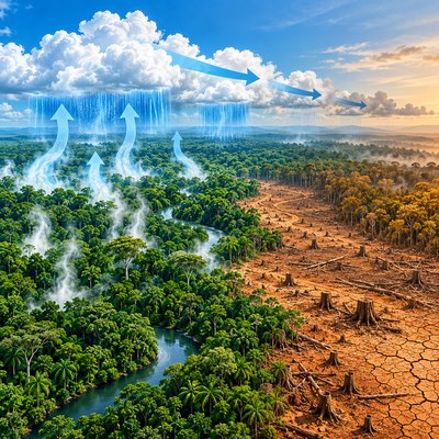
아마존의 나무는 비를 기다리기만 하지 않는다. 땅속 물을 끌어올려 잎으로 내보내고, 그 수증기는 바람을 타고 이동해 다시 비가 된다. 숲이 줄면 탄소를 저장할 공간만 사라지는 것이 아니라 숲을 지탱하던 거대한 물순환 장치도 약해진다.
[Key Message]
* 아마존의 기후 위험은 온난화와 벌채를 따로 계산해서는 보이지 않는다. 두 압력이 결합하면 숲의 대규모 생태 전환이 훨씬 낮은 온도에서 시작될 수 있다.
* 숲은 비의 수혜자이면서 생산자다. 나무가 줄면 증산과 수분 재활용이 약해지고, 바람 아래쪽 숲까지 더 건조해지는 연쇄효과가 생긴다.
* Nature 연구는 벌채를 제외할 때 3.7~4.0도였던 위험 범위가 벌채율 22~28%와 결합하면 1.5~1.9도로 낮아질 수 있다고 추정했다. 이 조건에서는 아마존 면적의 62~77%가 광범위한 전환 위험에 놓였다.
* 임계점은 어느 날 숲 전체가 동시에 무너진다는 뜻이 아니다. 일부 지역의 변화가 수분 연결망을 타고 수백에서 수천 킬로미터 떨어진 지역으로 번지는 자기증폭적 위험을 뜻한다.
* 배출 감축만큼 벌채 중단과 훼손지 복원이 중요하다. 특히 바람길의 상류에 있는 숲을 지키고 복원하는 일은 멀리 떨어진 농업과 물 안보까지 보호하는 기후정책이다.
***
나무가 비를 만드는 숲
아마존을 거대한 물탱크로 생각하면 절반만 맞다. 더 정확한 비유는 물을 끌어올리고, 공기 중으로 밀어 보내며, 대륙 안쪽으로 운반하는 살아 있는 펌프다. 대서양에서 들어온 습한 공기가 숲에 비를 뿌리면 나무는 뿌리로 물을 흡수하고 잎의 기공을 통해 다시 수증기로 내보낸다. 이 수증기는 바람을 타고 서쪽과 남쪽으로 이동한 뒤 또 다른 비가 된다.
이 과정은 증발산(evapotranspiration)과 대기 수분 재활용으로 설명된다. 연구에 따르면 아마존 숲이 받는 강수의 지역별 최대 절반가량이 유역 내부에서 만들어질 수 있다. 특히 숲 위로 솟은 큰 나무들은 증산되는 물의 약 71%를 담당하며, 강수의 약 26%를 대기로 되돌리는 데 기여한다. 거목 한 그루는 탄소 저장고인 동시에 하늘로 물을 보내는 고성능 분수인 셈이다.
문제는 벌목기가 나무 한 그루만 가져가지 않는다는 데 있다. 잎이 사라지면 수증기 공급이 줄고, 햇빛을 가리던 수관이 없어지면서 지표는 더 뜨거워진다. 숲이 목초지나 경작지로 바뀌면 뿌리가 얕아지고 건기에도 물을 끌어올리던 능력이 약해진다. 같은 지역에서 비가 덜 내리고 건기가 길어지면 남아 있는 나무도 더 큰 수분 스트레스를 받는다.
그래서 아마존의 벌채는 토지 면적의 단순한 뺄셈이 아니다. 한 지역에서 끊어진 수분 공급이 바람을 따라 다른 지역의 비를 줄이는 네트워크 손상이다. 수도관 한 구간이 막히면 멀리 있는 수도꼭지의 수압까지 떨어지는 것처럼, 동쪽과 남쪽의 벌채가 서쪽과 남서쪽 숲의 안정성을 흔들 수 있다.
온도계만 봐서는 놓치는 위험
아마존의 임계점을 둘러싼 논의는 오랫동안 지구 평균기온이 몇 도 오르면 숲이 버티지 못하는가에 집중했다. 기존 지구시스템 모델은 대체로 산업화 이전보다 2~6도 높은 범위에서 중대한 변화 가능성을 제시했다. 그러나 실제 숲은 온도 하나에만 반응하지 않는다. 강수량, 건기의 길이와 강도, 화재, 벌채 위치, 식생의 적응력이 동시에 작용한다.
니코 분더링(Nico Wunderling), 보리스 작셰프스키(Boris Sakschewski), 요한 록스트룀(Johan Rockstrom) 등이 참여한 연구팀은 이 복합 작용을 한 화면에 올렸다. 2026년 Nature에 발표한 연구는 동역학계 모델과 대기 수분 추적 모델을 결합해, 한 지역의 숲 변화가 수분 이동망을 통해 다른 지역에 어떤 영향을 주는지 계산했다. 아마존을 고립된 격자의 모음이 아니라 서로 비를 주고받는 연결망으로 본 것이 핵심이다.
연구팀은 공유사회경제경로(Shared Socioeconomic Pathways, SSP)에 따른 기후 자료를 사용했다. 노르웨이 지구시스템모델 2(Norwegian Earth System Model version 2, NorESM2)가 제공한 강수·증발·바람 자료 위에서 수분 입자의 이동을 추적했다. 아마존 416개 격자에서 증발한 물을 4시간 간격으로 따라가며, 어느 격자에 비로 돌아가는지 계산한 수분 입자는 10억 개를 넘었다.
숲의 안정성은 연평균 강수량과 최대누적수분결핍(Maximum Cumulative Water Deficit, MCWD), 건기의 지속시간을 바탕으로 평가했다. 한 해의 가뭄이 만든 충격과 장기적인 체제 변화를 구분하기 위해 10년 평균도 사용했다. 여기에 2020년 약 18%에서 2050년 약 35%까지 벌채가 늘어나는 강한 시나리오를 겹쳐 온난화만 있을 때와 비교했다.
3.7도가 1.5도로 내려간 까닭
벌채를 고려하지 않은 실험에서는 지구 평균기온이 산업화 이전보다 3.7~4.0도 높아질 때 아마존의 대규모 안정성 상실 위험이 뚜렷해졌다. 이 범위에서는 유역의 최대 약 3분의 1이 전환 위험에 놓였다. 숫자만 보면 아직 거리가 있어 보일 수 있다. 그러나 벌채를 더하자 위험의 시간표가 크게 바뀌었다.
유역 전체의 벌채율이 22~28%에 이르고 지구 평균기온이 1.5~1.9도 상승하는 조건에서 광범위한 전환이 나타났다. 모의실험에서 영향을 받는 면적은 62~77%에 달했다. 현재의 온난화 수준과 멀지 않은 범위에서 토지 이용이 안전 여유를 크게 깎을 수 있다는 뜻이다. 숲을 베는 행위가 온도계의 위험 눈금을 아래로 끌어내린 셈이다.
이 결과를 아마존의 23%가 사라지는 날 숲 전체가 곧바로 초원으로 변한다는 예보로 읽어서는 안 된다. 연구가 계산한 것은 특정 조건이 오래 지속될 때 새로운 생태 상태로 이동할 가능성이 커지는 안정성의 변화다. 실제 전환이 완전히 드러나는 데에는 수십 년에서 수백 년이 걸릴 수 있으며 지역별 반응도 다르다.
그럼에도 숫자가 주는 경고는 분명하다. 위험은 온난화와 벌채의 단순 합이 아니라 곱셈에 가깝다. 더운 공기는 증발 요구량을 키우고, 벌채는 나무가 공급하던 수증기를 줄인다. 두 변화가 동시에 일어나면 남은 숲은 위에서 더 뜨겁게 압박받고 아래에서는 물 공급까지 줄어드는 이중 부담을 떠안는다.
숲의 도미노는 바람을 타고 쓰러진다
이번 연구에서 가장 눈에 띄는 대목은 직접적인 가뭄보다 연쇄효과의 비중이다. 벌채를 제외한 실험에서도 전환 원인의 87.5%가 수분 네트워크를 통한 연쇄 전환으로 나타났다. 벌채를 포함하면 그 비중은 99%까지 높아졌다. 최초의 균열보다 균열이 연결망을 따라 퍼지는 과정이 더 큰 위험을 만든다는 뜻이다.
예를 들어 아마존 동남부에서 숲이 줄면 그 지역이 대기로 보내던 수증기가 감소한다. 바람 아래쪽의 숲은 비를 덜 받고, 건기에는 토양 수분을 더 빨리 소진한다. 약해진 숲이 다시 증산을 줄이면 그 다음 지역의 강수도 줄어든다. 한 지역의 가뭄이 수백에서 수천 킬로미터를 이동하는 생태 도미노가 된다.
어디를 베느냐가 얼마나 베느냐만큼 중요한 이유도 여기에 있다. 연구의 강한 벌채 시나리오는 현재 벌채 전선이 형성된 남부와 동부에서 중앙부로 훼손이 확장되는 모습을 가정했다. 이 지역은 주요 바람길의 상류에 있어 수분 공급의 연결 고리를 끊을 가능성이 크다. 같은 면적을 잃더라도 수분 흐름의 관문을 훼손하면 충격은 더 멀리 퍼진다.
이 관점은 산림정책의 지도를 바꾼다. 보호지역을 생물다양성이 높은 곳이나 탄소가 많은 곳만으로 선정해서는 충분하지 않다. 대기 중 물이 어디에서 만들어져 어디로 이동하는지까지 살펴야 한다. 숲의 가치를 나무 수와 탄소량뿐 아니라 ‘비를 전달하는 위치’로 평가해야 한다.
농장과 발전소까지 이어지는 비의 공급망
아마존의 물순환은 숲 안에서 끝나지 않는다. 대기 중 수분은 브라질 남부와 볼리비아, 파라과이, 아르헨티나의 라플라타강 유역까지 이동한다. 이 지역에는 대규모 농경지와 도시, 수력발전 시설이 밀집해 있다. 아마존이 약해지면 산림보전의 문제가 곡물 생산과 전력, 식수의 문제로 번질 수 있다.
대두 농장을 떠올려보자. 숲을 밀어 경작지를 늘리면 단기적으로 심을 땅은 많아진다. 하지만 벌채가 강수를 줄이고 건기를 길게 만들면 파종 시기는 불안정해지고 관개비용은 오른다. 농지를 얻기 위해 비를 만드는 기반시설을 해체하는 역설이 생긴다. 경작 면적의 확대가 생산 안정성을 해칠 수 있는 것이다.
수력발전도 같은 위험에 놓인다. 저수지의 발전량은 단순히 댐 주변의 날씨가 아니라 넓은 유역의 강수에 좌우된다. 수분 재활용이 약해져 하천 유량의 계절 변동이 커지면 전력 운영자는 예비전력과 다른 발전원을 더 확보해야 한다. 산림 파괴 비용은 목재나 탄소 가격에만 나타나지 않고 전력요금과 보험료, 식품 가격에 숨어 들어간다.
도시도 이 연결망에서 자유롭지 않다. 가뭄으로 하천과 저수지의 수위가 낮아지면 상수도 운영비가 늘고, 화물 운송에 의존하는 강의 수위가 내려가 물류가 지연될 수 있다. 산불 연기는 수천 킬로미터 떨어진 대도시의 공기질까지 흔든다. 숲 한쪽의 토지 이용 결정이 다른 나라의 예산과 기업의 영업계획에까지 번지는 이유다.
기업의 공급망 관리에도 새로운 질문이 생긴다. 원료가 불법 벌채와 직접 연결되지 않았다는 확인만으로 충분한가. 합법적으로 개간된 농지라도 중요한 수분 통로를 훼손하면 장기적으로 생산 기반을 약화할 수 있다. 추적가능성은 토지의 법적 출처를 넘어 물순환에 미치는 위치별 영향까지 확장될 필요가 있다.
임계점은 예언이 아니라 위험지도다
모델 연구는 미래를 사진처럼 보여주지 않는다. 가정을 넣어 가능한 경로를 비교하는 실험실에 가깝다. 이번 연구도 식생 변화를 단순화했고, 화재의 확산을 명시적으로 모의하지 않았으며, 수문 입력자료를 하나의 지구시스템 모델에 크게 의존했다. 나무의 적응 능력과 이산화탄소 비료효과에도 불확실성이 남아 있다.
벌채 시나리오의 기초자료가 다소 오래됐다는 점도 연구팀이 인정한 한계다. 도로 포장과 보호구역 무시를 가정한 강한 경로이므로 실제 정책이 개선되면 같은 결과가 나타나지 않을 수 있다. 반대로 가뭄과 화재가 서로를 키우는 상호작용을 충분히 반영하지 않았으므로 위험을 보수적으로 잡았을 가능성도 있다.
따라서 22%나 1.5도를 절대적인 절벽으로 다뤄서는 안 된다. 중요한 것은 정확한 소수점이 아니라 안전 여유가 생각보다 좁고, 서로 다른 압력이 그 여유를 함께 소모한다는 구조다. 임계점 연구의 역할은 붕괴 날짜를 맞히는 것이 아니라 위험이 급격히 커지는 조건을 찾아 정책이 피해야 할 영역을 보여주는 데 있다.
연구팀은 적응력과 증발산 효과를 달리한 여러 민감도 분석과 대규모 몬테카를로 앙상블을 수행했다. 세부 수치는 달라져도 온난화와 벌채가 결합할 때 위험이 크게 앞당겨지고, 수분 네트워크의 연쇄효과가 지배적이라는 질적 결과는 유지됐다. 불확실성은 행동을 미룰 이유라기보다 여러 안전장치를 동시에 마련해야 할 이유가 된다.
숲을 지키는 일은 비의 보험을 드는 일
정책의 첫 번째 축은 온실가스 배출을 줄여 지구 평균기온 상승을 1.5도 아래로 묶는 것이다. 그러나 배출 감축만으로는 충분하지 않다. 아마존 내부의 벌채를 멈추지 못하면 현재에 가까운 온난화 수준에서도 숲의 안정성이 위험해질 수 있다. 세계의 기후정책과 남미의 토지정책은 같은 안전장치의 두 부품이다.
두 번째 축은 벌채 총량과 위치를 함께 관리하는 것이다. 수분 흐름의 상류, 건기 취약지역, 이미 조각난 숲을 우선 보호하면 같은 면적의 보전으로 더 큰 연쇄위험을 막을 수 있다. 도로를 어디에 놓고 농지를 어디까지 허용할지 결정할 때 탄소와 생물다양성뿐 아니라 대기 수분 연결망을 평가해야 한다.
여기에는 국경을 넘는 협력이 필요하다. 아마존 유역은 여러 국가에 걸쳐 있지만 수증기는 출입국 심사를 받지 않는다. 한 나라가 숲을 지키더라도 바람의 상류에 있는 다른 나라에서 벌채가 늘면 강수 안정성이 흔들릴 수 있다. 산림 감시자료와 수분 이동지도를 공유하고, 보전으로 얻는 편익을 함께 부담하는 금융장치가 필요한 까닭이다.
세 번째 축은 복원이다. 훼손된 숲을 되살리면 증산과 수분 재활용을 회복시켜 온난화에 대한 완충력을 높일 수 있다. 브라질은 복원 아크에서 약 1천200만 헥타르를 되살리는 구상을 추진해왔다. 재생림이 원시림의 생물다양성을 곧바로 대체하지는 못하지만, 끊어진 비의 공급망을 다시 잇는 데에는 의미 있는 역할을 할 수 있다.
아마존을 지키는 이유를 탄소 한 단어로만 설명하면 숲의 절반을 놓친다. 이 숲은 남미 대륙의 비를 순환시키는 자연 기반시설이며, 농업과 전력, 도시의 물을 떠받치는 보이지 않는 공공재다. 나무를 남겨두는 일은 개발을 포기하는 비용이 아니라 기후가 갑자기 다른 상태로 넘어가지 않도록 보험료를 내는 선택이다. 아마존의 미래는 온도계뿐 아니라 전기톱이 멈추는 속도에 달려 있다.
Reference
Wunderling, Nico et al., May 2026, Deforestation-induced Drying Lowers Amazon Climate Threshold, Nature
The Amazon Loses Rain as It Loses Trees
- Deforestation disrupts the forest’s water cycle and brings the climate threshold closer than expected
Amazonian trees do not merely wait for rain. They draw water from the soil, release it through their leaves, and help turn that vapour into rain again. When forest disappears, the Amazon loses not only carbon storage but also part of the vast water-circulation system that keeps the forest alive.
[Key Message]
* Amazon climate risk cannot be understood by calculating warming and deforestation separately. When the two pressures combine, large-scale ecological transitions can begin at much lower warming levels.
* The forest is both a recipient and a producer of rain. Fewer trees weaken transpiration and moisture recycling, allowing drying to spread into forests far downwind.
* The Nature study estimated that a danger range of 3.7?4.0 degrees Celsius without deforestation could fall to 1.5?1.9 degrees when combined with 22?28 percent deforestation. Under those conditions, 62?77 percent of the Amazon area faced widespread transition risk.
* A tipping point does not mean that the entire forest collapses on the same day. It describes a self-amplifying risk in which changes in one region spread through the moisture network over hundreds or thousands of kilometres.
* Stopping deforestation and restoring degraded land matter as much as cutting emissions. Protecting and rebuilding forests upwind is climate policy that also safeguards distant agriculture and water security.
***
The Forest That Makes Rain
It is only partly correct to imagine the Amazon as a giant water tank. A better metaphor is a living pump that draws up water, pushes it into the atmosphere, and transports it deep into the continent. Moist air arriving from the Atlantic drops rain on the forest. Trees absorb the water through their roots and release it again as vapour through leaf pores. Winds carry that vapour westward and southward, where it becomes rain once more.
This process is known as evapotranspiration and atmospheric moisture recycling. Research indicates that, depending on location, as much as half of Amazon forest rainfall can be generated within the basin. Large emergent trees are especially important: they account for about 71 percent of transpired water and help recycle roughly 26 percent of rainfall back into the atmosphere. A giant tree is both a carbon store and a high-capacity fountain feeding the sky.
The problem is that a logging machine removes more than a tree. Fewer leaves mean less vapour, while the loss of canopy exposes the ground to stronger heat. When forest becomes pasture or cropland, roots become shallower and lose some ability to draw water during the dry season. Less rainfall and a longer dry season then place even the remaining trees under greater water stress.
Deforestation is therefore not a simple subtraction of land area. It damages a network in which moisture lost in one place can reduce rainfall elsewhere along the prevailing winds. Just as a blockage in one section of pipe lowers pressure at a distant tap, forest loss in the east and south can undermine stability in the western and southwestern Amazon.
The Risk a Thermometer Misses
Discussion of an Amazon tipping point has long focused on how many degrees of global warming the forest can withstand. Earlier Earth-system models generally placed major change somewhere between two and six degrees Celsius above pre-industrial levels. Yet real forests do not respond to temperature alone. Rainfall, the length and intensity of the dry season, fire, the location of clearing, and vegetation adaptation all act together.
A team including Nico Wunderling, Boris Sakschewski, and Johan Rockstrom placed these interactions in one framework. Published in Nature in 2026, the study combined a dynamical-systems model with atmospheric moisture tracking to calculate how forest change in one location affects other regions through moisture flows. Its central innovation was to treat the Amazon not as isolated grid cells but as a connected network that exchanges rainfall.
The researchers used climate data from the Shared Socioeconomic Pathways (SSPs). They tracked moisture on precipitation, evaporation, and wind fields generated by the Norwegian Earth System Model version 2 (NorESM2). Starting from 416 grid cells across the Amazon and updating movements every four hours, the researchers followed more than one billion moisture parcels to determine where evaporated water returned as rain.
Forest stability was assessed through mean annual precipitation, Maximum Cumulative Water Deficit (MCWD), and dry-season duration. Ten-year averages helped distinguish a shock from a single drought year from a persistent system shift. The team then overlaid a severe pathway in which deforestation rose from about 18 percent in 2020 to about 35 percent in 2050 and compared it with warming-only experiments.
How 3.7 Degrees Fell to 1.5
In experiments excluding deforestation, the risk of large-scale stability loss became pronounced when global mean temperature reached 3.7?4.0 degrees Celsius above the pre-industrial level. Up to roughly one-third of the basin faced transition risk in this range. That number might appear comfortably distant. Adding deforestation, however, dramatically changed the timetable.
Widespread transitions appeared when basin-wide deforestation reached 22?28 percent while global warming reached 1.5?1.9 degrees. In the simulations, 62?77 percent of the Amazon area was affected. Land use could therefore consume a large share of the forest’s safety margin at warming levels close to the present. Cutting trees effectively pulled the danger mark lower on the thermometer.
The result should not be read as a forecast that the entire forest becomes savanna the day Amazon loss reaches 23 percent. The model estimates how stability changes and how the probability of a new ecological state grows when particular conditions persist. A full transition can take decades or centuries to emerge, and responses vary greatly by region.
The warning is nevertheless clear. Warming and deforestation interact more like multiplication than simple addition. Warmer air raises evaporative demand, while clearing reduces the vapour supplied by trees. When both changes occur, the remaining forest faces pressure from greater heat above and shrinking water supply below.
The Forest Dominoes Fall With the Wind
The most striking result concerns cascading effects rather than direct drought alone. Even without deforestation, 87.5 percent of simulated transitions were attributed to cascades through the moisture network. With deforestation included, the share rose to 99 percent. The spread of the fracture through the network mattered more than the first fracture itself.
Consider forest loss in the southeastern Amazon. The cleared area sends less vapour into the atmosphere. Downwind forests receive less rain and exhaust soil moisture faster during the dry season. As the weakened forest reduces its own transpiration, rainfall declines in the next region. A local drought becomes an ecological line of dominoes extending hundreds or thousands of kilometres.
This explains why where trees are removed can matter as much as how many are removed. The severe pathway assumed that clearing would expand from the current arc of deforestation in the south and east towards the central Amazon. These upwind areas can sever crucial links in the moisture supply chain. Losing the same area at a strategic gateway can send impacts much farther.
This perspective changes the map of forest policy. Protected areas cannot be selected only for biodiversity or carbon density. Policymakers must also examine where atmospheric water originates and where it travels. The value of forest needs to include not just tree numbers and stored carbon, but also its position in the delivery of rain.
A Rain Supply Chain Reaching Farms and Power Plants
Amazon moisture circulation does not stop at the forest boundary. Atmospheric water travels towards southern Brazil, Bolivia, Paraguay, and the Rio de la Plata basin in Argentina. These regions contain major croplands, cities, and hydropower facilities. A weaker Amazon can turn a conservation problem into a problem of grain output, electricity, and urban water supply.
Imagine a soybean farm. Clearing forest provides more land to plant in the short term. Yet if that clearing reduces rainfall and lengthens the dry season, planting dates become less reliable and irrigation costs rise. Land is gained by dismantling the infrastructure that produces rain. Expanding cultivated area can make agricultural output less stable.
Hydropower faces the same exposure. Reservoir output depends not only on weather around a dam but on precipitation across a wide catchment. If weakened moisture recycling increases seasonal volatility in river flow, grid operators need more reserve capacity and alternative generation. The cost of forest loss appears not only in timber and carbon prices, but quietly in electricity bills, insurance premiums, and food prices.
Cities are not insulated from this network. Falling river and reservoir levels raise the cost of operating water systems, while lower navigable rivers can delay freight. Smoke from forest fires can degrade air quality in metropolitan areas thousands of kilometres away. A land-use decision in one part of the forest can therefore reach the public budget and corporate operating plans of another country.
Corporate supply-chain management also faces a new question. Is it enough to verify that a commodity is not directly linked to illegal clearing? Even legally converted land can weaken long-term production if it damages a critical moisture corridor. Traceability may need to expand from the legal origin of land to the location-specific effects on the water cycle.
A Tipping Point Is a Risk Map, Not a Prophecy
A model does not photograph the future. It is closer to a laboratory for comparing possible pathways under explicit assumptions. This study simplifies vegetation shifts, does not explicitly simulate the spread of fire, and relies heavily on hydrological input from one Earth-system model. Uncertainty also remains around forest adaptation and carbon-dioxide fertilization.
The researchers also acknowledge that the underlying severe-deforestation dataset is somewhat dated. It assumes road paving and little protection from designated reserves, so better policy could prevent the same outcome. Conversely, the model may be conservative because it does not fully represent the mutually reinforcing relationship between drought and fire.
Numbers such as 22 percent or 1.5 degrees should therefore not be treated as an exact cliff edge. The important finding is structural: the safety margin may be narrower than assumed, and multiple pressures spend that margin together. Tipping-point research is valuable not because it predicts a collapse date, but because it maps the conditions in which risk rises sharply and identifies zones policy should avoid.
The team conducted a large Monte Carlo ensemble and sensitivity tests using different assumptions about adaptation and evapotranspiration. Precise values shifted, but the qualitative findings remained: combining warming with clearing moved danger forward, while cascades through the moisture network dominated. Uncertainty is not a reason to delay action; it is a reason to install several safeguards at once.
Protecting Forest Is Buying Rain Insurance
The first policy pillar is to reduce greenhouse-gas emissions and keep global warming below 1.5 degrees Celsius. Emissions cuts alone, however, are insufficient. If Amazon deforestation continues, forest stability can become dangerous at warming levels close to today’s. Global climate policy and South American land policy are two components of the same safety system.
The second pillar is to manage both the amount and location of clearing. Prioritizing upwind moisture sources, dry-season hotspots, and fragmented forests can reduce cascading risk more efficiently. Decisions about roads and agricultural expansion should assess atmospheric moisture connections alongside carbon and biodiversity.
That requires cooperation across borders. The Amazon basin spans several countries, but water vapour does not pass through immigration control. Even if one country protects its forests, increased clearing in an upwind neighbour can weaken rainfall stability. Governments need to share forest-monitoring data and moisture-flow maps while developing finance that distributes the benefits and costs of conservation.
The third pillar is restoration. Recovering degraded forest can rebuild transpiration and moisture recycling, strengthening the buffer against warming. Brazil has advanced plans to restore roughly 12 million hectares in an Arc of Restoration. Regrowth cannot immediately replace the biodiversity of primary forest, but it can help reconnect a broken rain supply chain.
Explaining Amazon protection only through carbon misses half of the forest’s function. The Amazon is natural infrastructure circulating rain across a continent and an invisible public good supporting farms, power systems, and cities. Leaving trees standing is not simply the cost of foregoing development; it is an insurance premium against the climate shifting abruptly into another state. The Amazon’s future depends not only on the thermometer, but on how quickly the chainsaws stop.
Reference
Wunderling, Nico et al., May 2026, Deforestation-induced Drying Lowers Amazon Climate Threshold, Nature